


High-Level Meteorology
22
High-level meteorology applies near to and above the tropopause, which is the border between the troposphere and the stratosphere. It varies in altitude from about 20,000 feet over the poles to 55,000 to 65,000 feet over the equator. In mid-latitudes, it is approximately 37,000 feet, and this is its assumed level in the standard atmosphere.
The tropopause is characterized by a sudden change in the temperature lapse rate, with temperature above the tropopause no longer decreasing with altitude. Temperatures and winds vary significantly near the tropopause, and knowledge of these can help you achieve an efficient and comfortable flight.
Jet Streams
The tropopause is not a continuous “sheet” from the equator to the poles, but descends in a number of steps from overhead the equator to overhead the poles. These steps are like breaks in the tropopause with intensified temperature gradients. Often the winds reach maximum values in narrow jet stream tubes along these breaks in the tropopause, with narrow bands of windshear and severe turbulence.
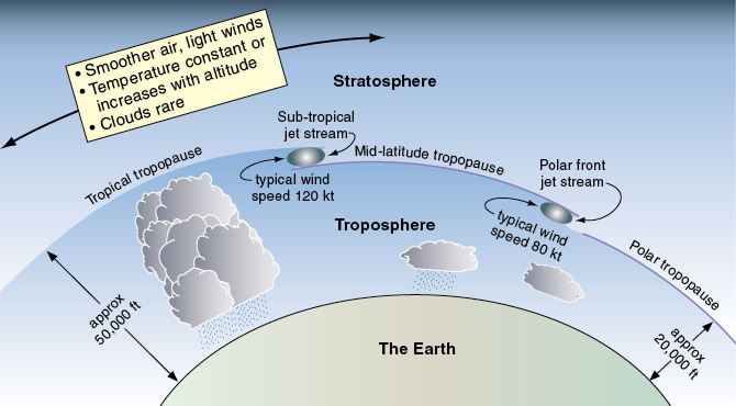
Figure 22-1 The tropopause.
In the winter months in the Northern Hemisphere the whole system moves further south (along with the sun), and the jet streams increase in strength. The position of the jet stream over North America varies, but it is (in general terms) further south and stronger in winter, and moves further north in summer and is somewhat weaker.
The position of the jet stream and its associated clear air turbulence (CAT) can sometimes be visually identified by long streaks of high-level cirrus clouds.
A jet stream is typically 5,000 feet thick and is associated with a deep low-pressure trough situated in the upper atmosphere near the tropopause. It may run in a curved path for thousands of miles around the earth at high altitude basically from west to east, but its path may meander quite a bit.
By definition, the wind strength in a jet stream is 50 knots or greater, with the strongest winds existing in the “core” of the jet stream tube. It is possible sometimes for a second and third jet stream to form.
High-flying jets often take advantage of the strong winds in the core of the jet stream when they are flying from west to east, perhaps giving them a tailwind of 100 knots or more, but avoid the jet stream when flying in the other direction.
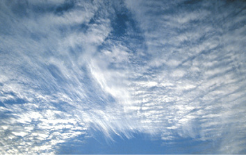
Figure 22-2 High cirrus cloud.
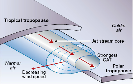
Figure 22-3 A cross-section of a jet stream.
CAT Near Jet Streams
Flying conditions can be smooth in a jet stream, but turbulence can be expected on its edges where it meets with slower moving air — so CAT is always a possibility near a jet stream. CAT is likely to be greatest on the edges of the jet stream core, especially on the cold polar side of the jet stream where there may be strong windshear, strong curvature in the airflow, and cold air moving in by advection associated with sharply curving strong upper-level troughs. A strong windshear can be expected on the low-pressure side of a jet stream core if speed at the core is greater than 110 knots.
A curving jet stream associated with a deep upper-level trough will create the greatest turbulence, especially during the winter months when the jet stream wind speeds are greater.
If encountering CAT associated with a jet stream at high altitude, it is good airmanship to report it, and also to determine from other pilot’s reports if smooth flight is being achieved at other levels. You might fly out of the CAT by climbing or descending several thousand feet, or by moving some miles laterally from the jet stream.
How a Jet Stream Forms
At the height of summer in the northern hemisphere, the subtropical jet all but disappears. During winter in the northern hemisphere, there is usually a well-defined polar jet and a well-defined subtropical jet. Jet streams flow in a curved sinusoidal path, flowing north of high pressure systems and south of low pressure systems.
Wind velocity changes with altitude, and this is caused by uneven temperatures in the horizontal. A warm air mass alongside a cold air mass (as is the case at the polar front) will be less dense and have relatively expanded pressure levels. Even though the pressures may be the same at ground level in the two air masses (with no pressure gradient), the pressure at altitude in the warm air mass will be greater than that at the same level in the cold air mass. A pressure gradient force will exist and a wind will be initiated. In general, the higher the altitude in the troposphere, the steeper the pressure gradient and the stronger the wind.
Once the wind starts to flow, the Coriolis force turns it to the right in the Northern Hemisphere. In the situation in figure 22-4, the wind will flow out of the page (from west to east as a westerly wind), and will be stronger at higher altitudes in the troposphere. If you look at weather charts and winds-aloft forecasts, you will often see westerlies that increase with altitude.
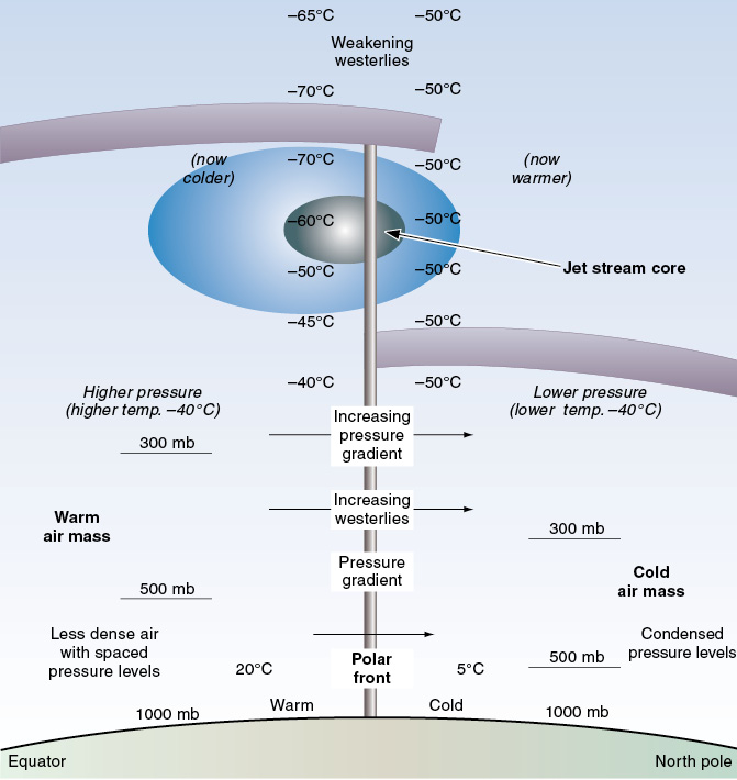
Figure 22-4 The polar front bringing cold air down from polar regions.
At the tropopause, temperature stops decreasing. Since the polar tropopause is lower than the mid-latitude tropopause, temperature above it will stop decreasing with altitude.
As well as the temperature gradient reversing with altitude, the pressure gradient will also start to reverse, and so the westerlies will start to weaken with increasing altitude above the tropopause, and may even become easterlies at great altitudes. The westerly winds reach their maximum intensity in the break between the two tropopause sheets, often blowing in a narrow jet stream tube at speeds well in excess of 100 knots.
Clouds at High Levels
High-altitude cirriform clouds which form in the cold air at high levels usually consist of ice crystals, and so generally do not create a significant icing hazard, although you may experience continuous turbulence. Streaks of cirrus clouds may be associated with a jet stream. It is also possible for strong thunderstorms to punch their way up to high levels, even above the tropopause, creating the usual cumulonimbus problems for high-flying pilots.
Haze layers sometimes exist at high levels near the tropopause, consisting of cirrus clouds with a low density of ice crystals. They may not be visible from the ground but, when flying in them, your visibility might be greatly restricted and the ride may not be smooth. Sometimes both visibility and smoothness of ride can be improved by climbing above the haze, or by descending beneath it.
Water vapor from the exhausts of high-flying jets sometimes condenses in the cold air at high altitudes to form exhaust condensation trails, known as contrails.
Review 22
High-Level Meteorology
1. What is a jet stream?
2. What defines the tropopause?
3. What is the average altitude of the tropopause in mid-latitudes?
4. How does the jet stream in the summer compare to that in the winter?