


Chapter 1
Weather
Table of Contents
The Earth’s AtmosphereHigh Altitude Weather
Temperature
Wind
Moisture and Precipitation
Air Masses, Fronts, Stability
Clouds
Fog
Turbulence
Thunderstorms
Microbursts
Icing
Structural and Induction Icing
Hazards of Structural Icing
Frost and Snow
Deice and Anti-Ice
Wind Shear
The Earth’s Atmosphere
We classify the atmosphere into layers, or spheres, by characteristics exhibited in these layers. The troposphere is the layer from the surface to an average altitude of about 7 miles (37,000 feet). It is characterized by an overall decrease of temperature with increasing altitude. The height of the troposphere varies with latitude and season. It slopes from about 20,000 feet over the poles to about 65,000 feet over the Equator; and it is higher in summer than in winter.
At the top of the troposphere is the tropopause, a very thin layer marking the boundary between the troposphere and the layer above. It is characterized by an abrupt change in temperature lapse rate.
Above the tropopause is the stratosphere. This layer is typified by relatively small changes in temperature with height except for a warming trend near the top. See Figure 1-1.

High Altitude Weather
The jet stream is a river of high speed winds (50 knots or more) associated with the tropopause. The location of the jet stream changes seasonally. In the winter, the jet stream moves south and increases in velocity. During the summer, the jet stream moves north and slows.
Temperature
The major source of all weather is the sun. Changes or variations of weather patterns are caused by the unequal heating of the Earth’s surface. In aviation, surface and aloft temperature is measured in degrees Celsius (°C).
Standard temperature is 15°C at sea level. To calculate International Standard Atmosphere (ISA), use the average lapse rate of 2°C per 1,000 feet.
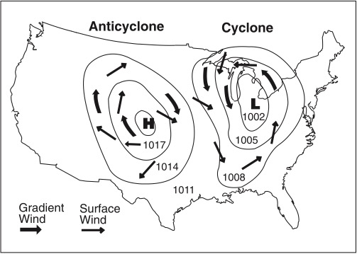
Wind
The rules in the Northern Hemisphere are:
1. Air circulates in a clockwise direction around a high pressure system.
2. Air circulates in a counterclockwise direction around a low pressure system.
3. The closer the isobars are together, the stronger the wind speed.
4. Due to surface friction (up to about 2,000 feet AGL), surface winds do not exactly parallel the isobars, but move outward from the center of the high toward lower pressure.
5. Coriolis force is at a right angle to wind direction and directly proportional to wind speed. The force deflects air to the right in the Northern Hemisphere.
Moisture and Precipitation
Air contains moisture (water vapor). The water vapor content of air can be expressed in two different ways: relative humidity and dew point.
Relative humidity relates the actual water vapor present in the air to that which could be present. Temperature largely determines the maximum amount of water vapor the air can hold. Warm air can hold more water vapor than cold air can. Air with 100 percent relative humidity is said to be saturated, and air with less than 100 percent is unsaturated.
Dew point is the temperature to which air must be cooled to become saturated by the water already present in the air.
When water vapor condenses on large objects, such as leaves, windshields, or airplanes, it will form dew. When it condenses on microscopic particles, such as salt, dust, or combustion by-products (condensation nuclei), it will form clouds or fog.
If the temperature and dew point spread is small and decreasing, condensation is about to occur. If the temperature is above freezing, fog or low clouds will be most likely to develop.
The growth rate of precipitation is enhanced by upward currents. Cloud particles collide and merge into a larger drop in the more rapid growth process. This process produces larger precipitation particles and does so more rapidly than the simple condensation growth process. Upward currents also support larger drops.
If wet snow is encountered at your flight altitude, then the temperature is above freezing at your altitude. Since melting snow has been encountered, the freezing level must be at a higher altitude.
The presence of ice pellets at the surface is evidence that there is freezing rain at a higher altitude. Rain falling through colder air may become supercooled, freezing on impact as freezing rain; or it may freeze during its descent, falling as ice pellets.
Air Masses, Fronts, Stability
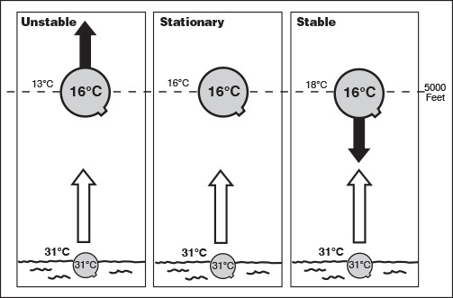
Atmospheric stability is defined as the resistance of the atmosphere to vertical motion. A stable atmosphere resists any upward or downward movement. An unstable atmosphere allows an upward or downward disturbance to grow into a vertical (convective) current.
Characteristics of unstable air are: cumuliform clouds, showery precipitation, rough air (turbulence), and good visibility, except in blowing obstructions. Characteristics of stable air are: stratiform clouds and fog, continuous precipitation, smooth air, and fair to poor visibility in haze and smoke.
Determining the stability of the atmosphere requires measuring the difference between the actual existing (ambient) temperature lapse rate of a given parcel of air and the dry adiabatic (3°C per 1,000 feet) lapse rate.
When a body of air (or air mass) comes to rest, or moves slowly over a large geographical area that has fairly uniform properties of temperature and moisture, the air mass acquires the temperature/moisture properties of that area it covers.
As air masses move out of their source regions, they come in contact with other air masses of different properties. The zone between two different air masses is a frontal zone or front. Across this zone, temperature, humidity and wind often change rapidly over short distances. The three principal types of fronts are the cold front, the warm front, and the stationary front. Frontal waves and cyclones (areas of low pressure) usually form on slow-moving cold fronts or stationary fronts.
Clouds
Cloud types are divided into four families: high clouds, middle clouds, low clouds, and clouds with extensive vertical development. The first three families are further classified according to the way they are formed. The high cloud family is cirriform and includes cirrus, cirrocumulus, and cirrostratus. They are composed almost entirely of ice crystals. Clouds formed by vertical currents in unstable air are cumulus, meaning “accumulation or heap.” They are characterized by their lumpy, billowy appearance. Clouds formed by the cooling of a stable layer are stratus, meaning “stratified or layered.” They are characterized by their uniform, sheet-like appearance.
In addition to the above, the prefix nimbo or the suffix nimbus means “raincloud.” A heavy, swelling cumulus type cloud which produces precipitation is a cumulonimbus. The high cloud family is cirriform and composed almost entirely of ice crystals.
Lenticular clouds are associated with a mountain wave. Crests of standing waves may be marked by stationary, lens-shaped clouds known as standing lenticular clouds. Mountain waves and lenticular clouds indicate strong turbulence.
Fog
Fog is a surface-based cloud composed of either water droplets or ice crystals. Fog is the most frequent cause of surface visibility below 3 miles, and is one of the most common and persistent weather hazards encountered in aviation. Fog may form by cooling the air to its dew point or by adding moisture to the air near the ground. A small temperature/dew point spread is essential to the formation of fog. An abundance of condensation nuclei from combustion products makes fog prevalent in industrial areas. Fog is classified by the way it is formed:
1. Radiation fog (ground fog) is formed when terrestrial radiation cools the ground, which in turn cools the air in contact with it. When the air is cooled to its dew point (or within a few degrees), fog will form. This fog will form most readily in warm, moist air over low, flatland areas on clear, calm nights.
2. Advection fog (sea fog) is formed when warm, moist air moves (wind is required) over colder ground or water. An example is an air mass moving inland from the coast in winter.
3. Upslope fog is formed when moist, stable air is cooled to its dew point as it moves (wind is required) up sloping terrain. Cooling will be at the dry adiabatic lapse rate of approximately 3°C per 1,000 feet.
Turbulence
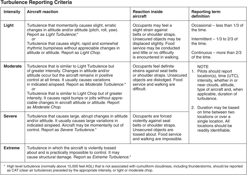
If severe turbulence is encountered either inside or outside of clouds, the airplane’s airspeed should be reduced to maneuvering speed and the pilot should attempt to maintain a level flight attitude because the amount of excess load that can be imposed on the wing will be decreased. An attempt to maintain a constant altitude will greatly increase the stresses that are applied to the aircraft. See Figure 1-5.

Thunderstorms
A thunderstorm is a local storm produced by a cumulonimbus cloud. It is always accompanied by lightning and thunder, usually with strong gusts of wind, heavy rain, and sometimes, with hail. Three conditions necessary for the formation of a thunderstorm are: sufficient water vapor, an unstable lapse rate, and an initial upward boost (lifting). The initial upward boost can be caused by heating from below, frontal lifting, or by mechanical lifting (wind blowing air upslope on a mountain).
There are three stages of a thunderstorm:
1. The cumulus stage is characterized by continuous updrafts, and these updrafts create low-pressure areas.
2. The mature stage is characterized by updrafts and downdrafts inside the cloud. Precipitation inside the cloud aids in the development of these downdrafts, and the start of rain from the base of the cloud signals the beginning of the mature stage. Thunderstorms reach their greatest intensity during the mature stage.
3. The dissipating stage is characterized predominantly by downdrafts.
Thunderstorms that generally produce the most intense hazard to aircraft are called squall-line thunderstorms. These nonfrontal, narrow bands of thunderstorms often develop ahead of a cold front.
Embedded thunderstorms are those that are obscured by massive cloud layers and cannot be seen.
Microbursts
Microbursts are small-scale intense downdrafts which, as they get near the ground, spread outward from the center in all directions. Maximum downdrafts at the center of a microburst may be as strong as 6,000 feet per minute. As your aircraft approaches, encounters, and exits a microburst it will experience a sudden increase in performance due to a headwind followed by a strong downdraft at the microburst center and then a severe loss of performance as the downdraft becomes a sudden tailwind. Since the initial headwind may be 45 knots and the tailwind also 45 knots, the total wind shear passing across the microburst would be 90 knots.
An individual microburst will seldom last longer than 15 minutes from the time it strikes the ground until dissipation. The horizontal winds continue to increase during the first 5 minutes with the maximum intensity winds lasting approximately 2–4 minutes.
Icing
One of the hazards to flight is aircraft icing. Pilots should be aware of the conditions conducive to icing, the types of icing, the effects of icing on aircraft control and performance, and the use and limitations of aircraft deice and anti-ice equipment. For ice to form, there must be moisture present in the air and the air must be cooled to a temperature of 0°C (32°F) or less. Aerodynamic cooling can lower the temperature of an airfoil to 0°C even though the ambient temperature is a few degrees warmer.
Ice is identified as clear, rime, or mixed. Rime ice forms if the droplets are small and freeze immediately when contacting the aircraft surface. This type of ice usually forms on areas such as the leading edges of wings or struts. It has a somewhat rough looking appearance and is a milky white color. Clear ice is usually formed from larger water droplets or freezing rain that can spread over a surface. This is the most dangerous type of ice since it is clear, hard to see, and can change the shape of the airfoil. Mixed ice is a mixture of clear ice and rime ice. It has the bad characteristics of both types and can form rapidly.
Structural and Induction Icing
There are two kinds of icing that are significant to aviation: structural icing and induction icing. Structural icing refers to the accumulation of ice on the exterior of the aircraft. Induction icing affects the powerplant operation. Structural icing occurs on an aircraft whenever supercooled droplets of water make contact with any part of the aircraft that is also at a temperature below freezing.
One inflight condition necessary for structural icing is visible moisture (clouds or raindrops). As the rain falls through air that is below freezing, its temperature begins to fall below freezing yet it does not freeze solid—i.e., freezing rain. The process requires the temperature of the rain to be above freezing before it becomes supercooled. Aircraft structural ice will most likely have the highest accumulation in freezing rain; therefore, an operational consideration if you fly into rain that freezes on impact is that temperatures are above freezing at some higher altitude.
Hazards of Structural Icing
The most hazardous aspect of structural icing is its aerodynamic effects. Ice can alter the shape of an airfoil. This can cause control problems, change the angle of attack at which the aircraft stalls, and cause the aircraft to stall at a significantly higher airspeed. Ice can reduce the amount of lift that an airfoil will produce and increase amount of drag by several times. It can partially block or limit control surfaces, which will limit or make control movements ineffective. If the extra weight caused by ice accumulation is too great, the aircraft might not be able to become airborne, and if in flight, might not be able to maintain altitude.
For this reason, regulations prohibit takeoff when snow, ice, or frost is adhering to wings, propellers, or control surfaces of an aircraft. Yet another hazard of structural icing is the possible uncommanded and uncontrolled roll phenomenon referred to as roll upset, which is associated with severe inflight icing. Therefore, pilots flying airplanes certificated for flight in known icing conditions should be aware that severe icing is a condition that is outside of the airplane’s certificated icing envelope.
Structural icing can also cause tailplane (empennage) stall. The tail can collect ice faster than the wing and because it is not visible to the pilot inflight, the situation could go undetected. A tailplane stall occurs when, same as with the wing, the critical angle of attack is exceeded. Since the horizontal stabilizer counters the natural nose-down tendency caused by the center of lift of the main wing, the airplane will react by pitching down, sometimes uncontrollably, when the tailplane is stalled. Application of flaps can aggravate or initiate the stall.
Because of this, the pilot should use caution when applying flaps during an approach if there is the possibility of icing on the tailplane. Ice buildup will cause the airplane to require more power to maintain cruise airspeed. Ice on the tailplane can cause diminished nose-up pitch control and heavy elevator forces, and the aircraft may buffet if flaps are applied. Ice on the rudder or ailerons can cause control oscillations or vibrations.
For an airplane to be approved for flight into icing conditions, the airplane must be equipped with systems that will adequately protect various components. Not all airplanes with these components are approved for flight into known icing; check your POH to know if your airplane has been certificated to operate in known icing conditions.
Frost and Snow
Frost is described as ice deposits formed on a surface when the temperature of the collecting surface is at or below the dew point of the adjacent air, and the dew point is below freezing. Frost causes early airflow separation on an airfoil resulting in a loss of lift. Therefore, all frost should be removed from the lifting surfaces of an airplane before flight or it could prevent the airplane from becoming airborne.
Test data indicate that ice, snow, or frost formations having a thickness and surface roughness similar to medium or course sandpaper on the leading edge and upper surface of a wing can reduce wing lift by as much as 30 percent, and increase drag by 40 percent.
Deice and Anti-Ice
Deicing is a procedure in which frost, ice, or snow is removed from the aircraft in order to provide clean surfaces. This is often accomplished with pneumatic boots. Anti-icing is a process that provides some protection against the formation of frost or ice for a limited period of time.
Wind Shear
Wind shear is defined as a change in wind direction and/or speed in a very short distance in the atmosphere. This can occur at any level of the atmosphere and can be detected by the pilot as a sudden change in airspeed.
Low-level (low altitude) wind shear can be expected during strong temperature inversions, on all sides of a thunderstorm and directly below the cell. Low-level wind shear can also be found near frontal activity because winds can be significantly different in the two air masses which meet to form the front.
In warm front conditions, the most critical period is before the front passes. Warm front shear may exist below 5,000 feet for about 6 hours before surface passage of the front. The wind shear associated with a warm front is usually more extreme than that found in cold fronts.
The shear associated with cold fronts is usually found behind the front. If the front is moving at 30 knots or more, the shear zone will be 5,000 feet above the surface 3 hours after frontal passage.
There are two potentially hazardous shear situations:
1. Loss of tailwind—A tailwind may shear to either a calm or headwind component. In this instance, initially the airspeed increases, the aircraft pitches up, and altitude increases. Lower than normal power would be required initially, followed by a further decrease as the shear is encountered, and then an increase as glide slope is regained.
2. Loss of headwind—A headwind may shear to a calm or tailwind component. Initially, the airspeed decreases, the aircraft pitches down, and altitude decreases.