


19
Clouds
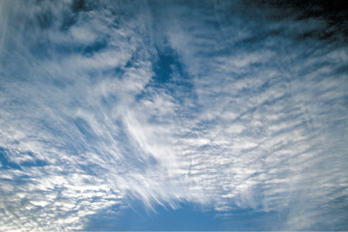
Figure 19-1 Clouds foretell much about flying conditions and trends.
A cloud is a visible aggregate of minute particles of water and/or ice in the free air. The effect of clouds on aviation, particularly on flight, is an important training topic for instrument-rated pilots.
Low stratus clouds formed in stable atmospheric conditions can sit low over the ground, possibly even on the ground as fog, and cause you to divert to an alternate destination. Towering cumulus clouds can form in unstable conditions due to moist air rising and can develop into one of the greatest hazards to an airplane: cumulonimbus clouds and thunderstorms. Clouds can be thought of as “signposts in the sky.” The location and look of a cloud can tell you a lot about what to expect in regard to turbulence, stability and visibility. Interpreting this information correctly helps you make good in-flight decisions.
The Naming of Clouds
those with extensive vertical development.
Clouds may take on many different forms, some of which continually change. They are classified into four families according to altitude and are named individually according to their nature. It is important to have an understanding of cloud classification because the meteorological forecasts and reports use this system to give you a picture of the weather:
1.High-level clouds have a base above approximately 20,000 feet and are composed mainly of ice crystals in the below freezing upper atmosphere (cirrus, cirrocumulus, cirrostratus).
2.Middle-level clouds have a base above approximately 6,500 feet (altocumulus, altostratus, nimbostratus).
3.Low-level clouds have a base below approximately 6,500 feet (stratocumulus, stratus, fair weather cumulus, nimbostratus).
4.Clouds with extensive vertical development (towering cumulus (TCU), cumulonimbus (CB), altocumulus castellanus (ACC)).
Clouds are named according to the following types:
- cirriform (or fibrous) — consisting mainly of ice crystals;
- cumuliform (or heaped) — formed by unstable air rising and cooling;
- stratiform (or layered) — formed by the cooling of a stable layer;
- nimbus (or rain-bearing);
- fractus (fragmented);
- castellanus (common base with separate vertical development, often in lines);
- lenticularis (lens-shaped, often formed in strong winds over mountainous areas).
For example, nimbostratus means stratified clouds from which rain is falling. Altocumulus is middle-level heaped clouds. Cumulus fractus is fragmentary cumulus clouds. Cirrostratus is high-level stratified clouds consisting of ice crystals. Standing lenticular altocumulus clouds are lens-shaped middle-level clouds residing in one position, usually over a mountain range in strong winds.
Nimbostratus is a hybrid cloud in terms of classification since its base can be low level or middle level, and it can have great vertical depth. Sometimes nimbostratus is 10,000 feet or even 15,000 feet thick, making it very dark when seen from underneath and capable of causing heavy rain for many hours.
Flying in clouds means poor visibility and the risk of icing — not a great risk in the high-level cirriform clouds consisting of ice crystals, but very great in clouds of extensive vertical development which may contain large supercooled water drops that will freeze on contact with a cold airplane.
Moisture in the Atmosphere
Clouds are formed when water vapor in the atmosphere condenses into water droplets or, in below freezing temperatures, into ice crystals. Water vapor is taken up into the atmosphere mainly by evaporation from the oceans and other bodies where water is present, or by sublimation directly from solid ice when the air overlies a frozen surface.
The Three States of Water
Water in its vapor state is not visible, but when the water vapor condenses to form water droplets we see it as cloud, fog, mist, rain or dew. Frozen water is also visible as high-level clouds, snow, hail, ice or frost. Water exists in three states — gas (vapor), liquid (water) and solid (ice).
Under certain conditions water can change from one state to another, absorbing heat energy if it moves to a higher energy state (from ice to water to vapor) and giving off heat energy if it moves to a lower energy state (vapor to water to ice). This heat energy is known as latent heat and is a vital part of any change of state. The absorption or emission of latent heat is important in meteorological processes such as cloud formation, and evaporation of rain (virga).
The three states of water, the names of the various transfer processes and the absorption or giving off of a latent heat are shown in figure 19-2.

Figure 19-2 The three states of water.
Relative Humidity
The amount of water vapor present in the air depends on the amount of evaporation, which will be greater over wet surfaces such as oceans and flooded ground than over a desert or continent.
The actual amount of water vapor in the air, known as humidity, is not as important as whether the air can support that water vapor or not. When a parcel of air is supporting as much water vapor as it can, it is said to be saturated and have a relative humidity of 100%.
Air supporting less than its full capacity of water vapor is said to be unsaturated, and will have a relative humidity of less than 100%.
In cloud and fog, the relative humidity is 100% and the air is saturated; over a desert, relative humidity might be 20%. The temperature of the air governs the amount of water that can be absorbed. At –20°F and below, air is essentially dry and unable to hold water vapor. At the other end of the scale in very hot conditions, up to 4% of the atmosphere can be water vapor.
Glaciation
Above a temperature of about -40° (Celsius or Fahrenheit — the two scales happen to cross at this temperature), water vapor in the free air essentially never sublimates directly into ice crystals. It nearly always goes through the liquid phase first. Whether and when the process of conversion into ice crystals starts (glaciation) depends initially on the content of the air (the aerosol). Therefore, condensation nuclei play a big role in the condensation and freezing process: liquid drops at below freezing temperatures in the free air do not freeze unless they have something to freeze on.
As the temperatures get colder, more substances become effective as freezing nuclei, and thus at colder temperatures the liquid phase may be very short lived, but it is still there. This is fundamental to the existence of supercooled clouds (liquid clouds at below freezing temperatures) which produce icing. An airplane makes a great freezing nucleus, and when one happens along into such a supercooled cloud, ice will start to deposit.
Once glaciation in a cloud starts, a struggle ensues between the creation of new liquid water by adiabatic lifting and the depletion of water by creation of ice crystals. Nature actually prefers the ice phase once it is present, because the saturation pressure over ice crystals is less than that over liquid water drops. Absent the creation of new liquid water (e.g., in a more or less quiescent stratus cloud), once glaciation starts it will go to completion in anywhere from a few minutes at warmer temperatures to probably less than a minute at cold temperatures. However, in the presence of energetic lift continuing to generate liquid water (e.g., in a wave cloud), liquid water at below freezing temperatures can remain present in the cloud (and thus the cloud can remain an aircraft icing cloud) indefinitely.
This process is fundamental to the existence of aircraft icing. If water vapor went directly to ice crystals in the free air at below freezing temperatures (sublimation), icing clouds would either not exist or at least be much rarer than they are.
Cloud Formation
Clouds are formed when air is cooled to its dewpoint temperature, and the excess water vapor condenses as liquid water or ice crystals, depending on temperature. The cooling of a parcel of air can occur by various means, such as:
- rising air cooling adiabatically as it expands; or
- air flowing over, or lying over, a cooling surface.
Dewpoint Temperature
How much water vapor a particular parcel of air can support depends on the air temperature — warm air is able to support more water vapor than cold air. If the temperature of the air falls, it is capable of holding less water vapor, and so will move closer to being saturated, its relative humidity will rise. Relative humidity increases greatly with a decrease in temperature.
The temperature at which the relative humidity reaches 100%, and the excess water vapor starts to condense as water droplets, is known as the dewpoint temperature. The condensation process may be delayed if there are insufficient condensation nuclei in the air, or conversely, certain types of condensation nuclei may induce condensation shortly before 100% relative humidity is reached. Typical condensation nuclei are small particles of hygroscopic (water-soluble) dust, salt, or other small particles. Clouds form only when the water vapor actually condenses.
A parcel of air that has a temperature higher than its dewpoint is unsaturated and its relative humidity is less than 100%, because it is capable of holding more moisture at its current temperature. The closer the actual temperature of the parcel of air is to its dewpoint, the closer it is to being saturated. As the spread between actual air temperature and the dewpoint temperature decreases as the air temperature falls, the relative humidity increases.
At its dewpoint, the air will be fully saturated. If it becomes cooler than its dewpoint, then the excess water vapor will condense as visible water droplets (or, in freezing temperatures below the frost point, deposit as ice crystals). The actual value of the dewpoint temperature for a particular parcel of air varies, depending on the amount of water vapor it contains. If the air is moist (for instance over an ocean), the dewpoint temperature may be quite high, say +25°C; if the air is dry, the dewpoint temperature may be quite low.
If the air temperature falls to a dewpoint temperature which is above freezing, the water vapor will condense as liquid water droplets and become visible as clouds, fog, or dew; if the dewpoint temperature is below freezing, the excess water vapor may change to ice crystals (like in high-level cirriform clouds, or frost on the ground on a below freezing night).
If the air in which clouds form is unable to support the water droplets (if they become too large and heavy), then the drops will fall as precipitation (rain, hail or snow).
Adiabatic Processes
The temperature of a gas is the measure of the cumulative total of kinetic energy, or the motion of individual molecules in the gas. This is measured by allowing the molecules to bump into the glass on a thermometer bulb, which transfers the energy to the mercury or alcohol in the thermometer. The mercury expands or contracts depending upon the amount of energy and we calibrate this to read temperature. In adiabatic processes, temperature can change as a result of pressure changes, even though heat energy is neither added to nor taken from the system. Expanding a gas and decreasing its pressure causes a lowering of temperature, because fewer molecules will collide with the measuring surface.
Conversely, compressing a gas and increasing its pressure will raise its temperature because more molecules will collide with the measuring surface. Placing your finger over the outlet of a bicycle pump illustrates that compressing air increases its temperature. Also, air that has been compressed and stored at room temperature will cool when it is released to the atmosphere and allowed to expand.
A common adiabatic process that involves the expansion of a gas and its cooling is when a parcel of air rises in the atmosphere. This can be initiated by the heating of the parcel of air over warm ground, causing it to expand and become less dense than the surrounding air, hence it will rise. A parcel of air can also be forced aloft as it blows over a mountain range, or as it is lifted over a front.
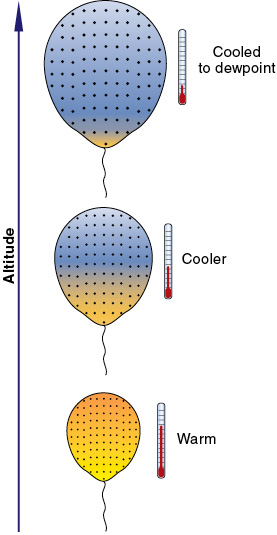
Figure 19-3 As air rises and expands,it cools adiabatically.
Unsaturated air will cool adiabatically at about 3°C/1,000 feet as it rises and expands. This is known as the dry adiabatic lapse rate (DALR). Air that is 12°C at ground level will cool adiabatically to 9°C if it is forced up to 1,000 feet AGL, and to 6°C at 2,000 feet AGL, provided it does not reach saturation point.
Cooler air can support less water vapor, so, as the parcel of air rises and cools, its relative humidity will increase. At the altitude where its temperature is reduced to the dewpoint temperature (relative humidity reaches 100%), water will start to condense and form clouds.
Above this altitude, the now-saturated air will continue to cool as it rises but, because latent heat will be given off as the water vapor condenses into the lower energy liquid state, the cooling will not be as great. The rate at which saturated air cools as it rises is known as the saturated adiabatic lapse rate (SALR) and may be assumed to have a value of approximately half the DALR, 1.5°C/1,000 feet. Air that is, say, 5°C inside a cloud, if it is forced 1,000 feet higher, will cool adiabatically to 3.5°C.
Note. At higher levels in the cloud where there is less water vapor to condense into water (since most of this has already occurred), there will be less latent heat given off and so SALR will increase.
Which Cloud Type Forms?
The structure or type of cloud that forms depends mainly on the stability of the air before lifting occurs.
Moist air that is unstable will continue rising, forming cumulus-type clouds with significant vertical development and turbulence, whereas moist air that is stable has no tendency to continue rising — it will form stratus-type clouds with little vertical development and little or no turbulence. Some stratus-type clouds, such as nimbostratus, can form in a thick layer. Dry air that is forced to rise, but does not cool to its dewpoint temperature, will not form clouds.
Unstable Air
As long as a parcel of air given vertical movement is warmer than its surroundings, it will continue to rise. Stability depends upon the ambient or environmental lapse rate of the air surrounding the rising air. If the lapse rate of the surrounding air is more than 3° per thousand, the situation is unstable whether or not air is rising through it. If the surrounding air has a lapse rate of less than 1.5, the situation could be called stable whether or not there is a rising parcel of air.
Characteristics of unstable air are:
- turbulence in the rising air;
- the formation of cumuliform clouds (heaped clouds);
- showery rain from these clouds, if there is precipitation with fairly large water droplets; and
- good visibility between the showers (caused by the rising air carrying any obscuring particles away).
Stable Air
If the rising parcel of air is cooler than the ambient air around it, then it will stop rising because its density will be greater than the surroundings. An atmosphere in which air tends to remain at the one level, or to sink, is called a stable atmosphere.
Characteristics of stable air are:
- the formation of stratiform clouds (layer-type) with little vertical development and steady, if any, precipitation with relatively small water droplets;
- poor visibility if there are any obscuring particles; and
- possibly smooth flying conditions with little or no turbulence.
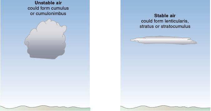
Figure 19-4 Cumuliform clouds in unstable conditions; stratiform clouds form in stable conditions.
The rate of temperature change as altitude is gained in the surrounding atmosphere (in the air that is not rising) is called the environmental lapse rate (ELR), the ambient lapse rate or the actual lapse rate. Its relationship to DALR and SALR is the main factor in determining the levels of the bases and tops of the clouds that form. A great decrease in ambient air temperature with altitude (a high ELR) encourages warm air to keep rising (an unstable situation) and form clouds of great vertical development. A lesser ELR may indicate a stable situation. The stability in the atmosphere depends on the ambient lapse rate.
The standard atmosphere, which is simply a theoretical measuring stick against which the actual atmosphere at any time or place can be compared, assumes an ambient lapse rate of 2°C/1,000 feet. The actual ELR in a real atmosphere, however, may differ greatly from this — it may be 1°C per 1,000 feet gain in altitude, or it may be 2.5°C per 1,000 feet gain in altitude. In a temperature inversion, the temperature will not decrease with altitude, but will increase. The actual environmental lapse rate varies from time to time and place to place.
Clouds Formed by Convection Caused by Heating
Cold air moving over or lying over a warm surface will be warmed from below, and so become less stable. It will tend to rise, causing turbulence and good visibility. If the air is moist and unstable, cumuliform clouds will develop as the air ascends and cools adiabatically to its dewpoint temperature.

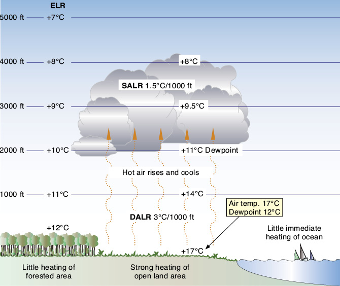
Figure 19-5 The temperature processes involved in the formation of a cumulus cloud.
The ascending unsaturated air will cool at the dry adiabatic lapse rate of 3°C/1,000 feet. The closer the air temperature is to the dewpoint, the lesser altitude it has to rise before condensing to form clouds. The dewpoint decreases at about 0.5°C/1,000 feet, which means that the air temperature/dewpoint spread will decrease at approximately 2.5°C/1,000 feet in rising unstable air.
For working in degrees Fahrenheit, DALR for unsaturated air is 5.4°F and dewpoint lapse rate is approximately 1°F, so they converge at approximately 4.4°F/1,000 feet (which is the same as 2.5°C/1,000 feet).
Example 19-1
If the temperature at a given level is 17°C and the dewpoint is 12°C, (a temperature/dewpoint spread of 5°C), then as the air rises this spread will decrease by approximately 2.5°C/1,000 feet. The temperature and dewpoint will have the same value at an altitude approximately 2,000 feet higher (5 ÷ 2.5 = 2).
The cloud base will form at a level 2,000 feet higher and the air, if it is still unstable, will continue to rise and form a heaped cumuliform cloud. Because it is now saturated, latent heat will be given off as more and more water vapor condenses into liquid water droplets. This reduces the rate at which the rising saturated air cools to the saturated adiabatic lapse rate of approximately 1.5°C/1,000 feet.
Example 19-2
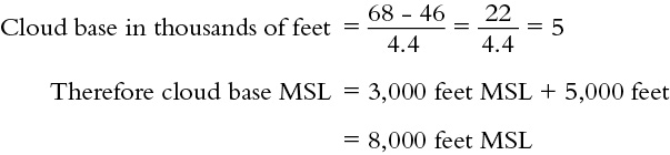
What is the appropriate base MSL of clouds if the temperature at 3,000 feet MSL is 68°F and the dewpoint is 46°F?
Clouds Formed by Orographic Uplift
Air flowing over mountains rises and is cooled adiabatically. If it cools to below its dewpoint temperature, then the water vapor will condense and clouds will form. Descending on the other side of the mountains, however, the airflow will warm adiabatically and, once its temperature exceeds the dewpoint for that parcel of air, the water vapor will no longer condense. The liquid water drops will now start to vaporize, and the clouds will cease to exist below this level.
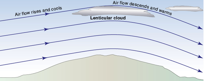
Figure 19-6 Lenticular cloud as a cap over a mountain.
The altitude at which the cloud base forms depends on the moisture content of the parcel of air and its dewpoint temperature. The cloud base may be below the mountain tops or well above them depending on the situation. Once having started to form, the cloud may sit low over the mountain as stratiform clouds (if the air is stable), or (if the air is unstable) the clouds will be cumuliform and may rise to high levels.
An almond-shaped or lens-shaped cloud that forms as a cap over the top of a mountain is known as a lenticular cloud. It will remain more or less stationary while the air flows through it, potentially at speeds of 50 knots or more.
Sometimes, when an airstream flows over a mountain range and there is a stable layer of air above, standing waves occur. This is a wavy pattern as the airflow settles back into a more steady flow and, if the air is moist, lenticular clouds may form in the crest of the lee waves, and a rotor or roll cloud may form at a low altitude. The presence of standing lenticular altocumulus clouds is a good indicator that strong mountain wave turbulence exists.
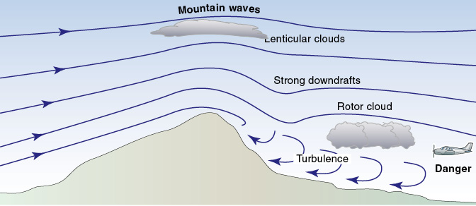
Figure 19-7 Mountain waves.
The Chinook (or Föhn) Wind Effect
If the air rising up a mountain range is moist enough to have a high dewpoint temperature and is cooled down to it before reaching the top of the mountain, then cloud will form on the windward side. If any precipitation occurs, moisture will be removed from the airflow and, as it descends on the lee side of the mountain, it will therefore be drier. The dewpoint temperature will be less and so the cloud base will be higher on the lee side of the mountain.
As the dry air beneath the cloud descends, it will warm at the dry adiabatic lapse rate of 3°C/1,000 feet, which is at a greater rate than the rising air cooled inside the cloud (saturated adiabatic lapse rate: 1.5°C/1,000 feet). The result is a warmer and drier wind on the lee side of the mountains. This noticeable effect is seen in many parts of the world, for example the föhn (pronounced “fern”) wind in Switzerland and southern Germany, from which this effect gets its name, the chinook wind which blows down the eastern slope of the Rocky Mountains, and the Santa Ana wind which blows from the east or northeast in southern California.
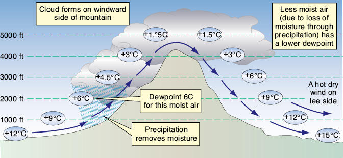
Figure 19-8 The chinook wind effect.
Clouds Formed by Turbulence and Mixing
As air flows over the surface of the earth, frictional effects cause variations in local wind strength and direction. Eddies are set up which cause the lower levels of air to mix — the stronger the wind and the rougher the earth’s surface, the larger the eddies and the stronger the mixing. The air in the rising currents will cool and, if the turbulence extends to a sufficient altitude, it may cool to the dewpoint temperature, water vapor will condense to form liquid water droplets and clouds will form.
The descending air currents in the turbulent cloud layer will warm and, if the air’s dewpoint temperature is exceeded, the liquid water droplets that make up the clouds will return to the water vapor state. The air will dry out and clouds will not exist below this altitude. With turbulent mixing, stratiform clouds may form over quite a large area, possibly with an undulating base. They may be continuous stratus or broken stratocumulus.
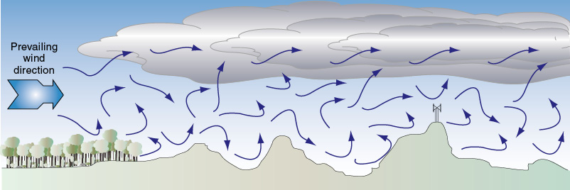
Figure 19-9 Formation of turbulence clouds.
Clouds Formed by the Widespread Ascent of an Air Mass
When two large masses of air of differing temperatures meet, the warmer and less dense air will flow over (or be undercut by) the cooler air. As the warmer air mass is forced aloft it will cool and, if the dewpoint temperature is reached, clouds will form. The boundary layer between two air masses is called a front.
Widespread lifting can also result from latitudinal pinching of an air mass as it moves to higher latitudes and has to crowd into a smaller area.
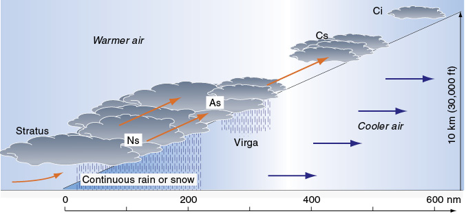
Figure 19-10 Cloud formation caused by widespread ascent.
Precipitation from Clouds
Precipitation refers to falling water that finally reaches the ground, including:
- rain consisting of liquid water drops;
- drizzle consisting of fine water droplets;
- snow consisting of branched and star-shaped ice crystals;
- hail consisting of small balls of ice;
- freezing rain or drizzle — liquid drops or droplets which freeze on contact with a cold surface (such as the ground or an aircraft in flight); and
- dew, frost or ice.
Intermittent or continuous precipitation (which often starts and finishes gradually, perhaps over a long period) is usually associated with stratiform clouds, including fine drizzle or snow from stratus and stratocumulus, heavy continuous rain or snow from nimbostratus, and steady rain from altostratus.
Rain or snow showers are associated with cumuliform clouds, and very heavy rain may fall from cumulonimbus storm clouds. The strong updrafts in cumulonimbus clouds carry the water droplets up to cooler levels where the condensation process continues and the drops grow in size and weight before they fall.
It is possible to use precipitation as a means of identifying the cloud type — rain or snow showers generally falling from cumuliform clouds, and non-showery precipitation such as steady rain, light snow or drizzle from stratiform clouds, mainly altostratus and nimbostratus.
For precipitation reported to be of light or greater intensity, the cloud will usually have to be at least 4,000 feet thick.
Rain (and snow) that falls from the base of clouds but evaporates before reaching the ground (hence is not really precipitation) is called virga. This can occur in areas of low humidity, often over deserts. One extremely important consequence of virga is that the evaporation of the rain absorbs latent heat from the air, creating a very cool and invisible parcel of air that may sink, or even plummet, quite rapidly toward the ground. This can sometimes result in a microburst, a lethal form of downflow that has brought many aircraft to grief.
Sometimes the only indications of a microburst are high-level virga and a ring of dust blown up on the ground. Microbursts are described in Chapter 21.
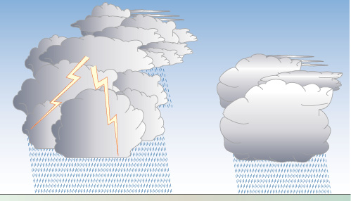
Figure 19-11 Showers fall from cumuliform clouds.
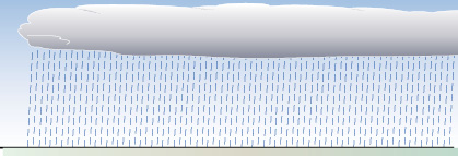
Figure 19-12 Non-showery (steady) precipitation from stratiform clouds.

Figure 19-13 Virga.
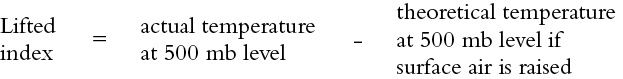
Lifted Index
The lifted index of a parcel of air is a measure of its stability. The lifted index is calculated by:
a. theoretically lifting the parcel of air from the surface to the 500 millibar pressure level, and calculating its temperature based on it cooling adiabatically by expansion; then
b. subtracting this calculated value from the actual temperature of the air already at the 500 millibar pressure level (approximately 18,000 feet MSL).
If the “lifted” parcel of air has a temperature less than that existing in the actual air at the 500 mb pressure level, then the parcel would have no tendency to keep rising, and the lifted index would have a positive value. A positive lifted index indicates stable air.
If the “lifted” air is warmer than the environmental air, then it will tend to keep on rising, and the lifted index would have a negative value. A negative lifted index indicates unstable air.
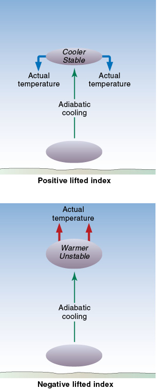
Figure 19-14 Positive and negative lifted indices.
Note. The lifted index only deals with temperatures at the surface and the 500 mb level (FL180). It does not describe what may be happening between those two points, nor does it deal with the amount of moisture in the air. Additional information is needed to determine the stability of the atmosphere as a whole.
Review 19
Clouds
1. Name the four families of clouds.
2. What clouds have their bases above approximately 20,000 feet?
3. What clouds have their bases below approximately 6,500 feet?
4. What do the suffix nimbus and the prefix nimbo, used in naming clouds, indicate?
5. Which suffix is often used to identify clouds that are broken into fragments?
6. What are clouds formed in strong winds over mountains known as?
7. What is the temperature to which air must be cooled to become saturated?
8. As a parcel of air is cooled, what happens to its relative humidity?
9. As a parcel of air is cooled to its dewpoint temperature, what change will occur to its relative humidity?
10. What does the amount of water vapor which air can hold largely depend on?
11. If air in contact with the ground cools to its dewpoint temperature, which is above freezing, what will happen to the excess water vapor?
12. If air in contact with the ground cools to its dewpoint temperature, which is below freezing, what will happen to the excess water vapor?
13. What conditions are necessary for frost to form?
14. What can delay the process of excess water condensing out of the air to form cloud or fog?
15. What sort of air is indicated by turbulence, good visibility, cumuliform clouds, and showery precipitation?
16. What sort of air is indicated by the presence of cumuliform clouds?
17. What sort of air is indicated by the presence of stratiform clouds?
18. How is atmospheric stability determined?
19. Which type of cloud is characterized by steady precipitation and little or no turbulence? Which type of air is this cloud formed in?
20. Poor visibility, stratiform clouds, and steady precipitation are more likely when the ambient lapse rate is:
a. high.
b. low.
21. The structure or the type of clouds, such as stratiform or cumuliform, is determined by:
a. the method by which the air is lifted.
b. the relative humidity of the air.
c. the prevalence of condensation nuclei.
d. the stability of the air before lifting occurs.
22. At what rate will unsaturated air being forced aloft cool?
23. At what rate will saturated air being forced aloft cool?
24. What is the ambient lapse rate in the theoretical standard atmosphere assumed to be? Can it vary from this value?
25. If an unstable air mass is forced to ascend a mountain slope, what cloud type is most likely to develop? How much, if any, vertical development will there be?
26. If a stable air mass is forced to ascend a mountain slope, what cloud type is most likely to develop? How much, if any, vertical development will there be?
27. What sort of cloud, flying conditions, and visibility can result from an unstable cold air mass moving over a warm surface?
28. What sort of cloud indicates very strong turbulence in mountain areas?
29. In a stationary group of clouds associated with a mountain wave, what sort of cloud can be the lowest?
30. Which clouds have the greatest turbulence?
31. What are high-level clouds mainly composed of ?
32. What sort of flying conditions often exist at and below the level of fair weather cumulus clouds?
33. What sort of flying conditions often exist above fair weather cumulus clouds (compared with below them)?
34. What is the presence of standing lenticular altocumulus over a mountain range a good indication of?
35. Which sort of cloud is drizzle or steady rain associated with?
36. Which sort of cloud are showers associated with?
37. What is the growth rate of raindrops enhanced by? Which sort of cloud is this associated with?
38. What is rain which evaporates before it reaches the ground called?
39. How significant is the risk of structural icing when flying in clouds of extensive vertical development? Why is this the case?
40. How significant is the risk of structural icing when flying in high-level cirriform clouds? Why is this the case?
41. For precipitation of light or greater intensity to occur, the clouds generally have to be at least:
a. 1,000 feet thick.
b. 2,000 feet thick.
c. 4,000 feet thick.
d. 10,000 feet thick.
42. What effect will evaporating rain have on the temperature?
43. Can very strong downdrafts exist beneath evaporating rain?
44. What is a very dangerous and localized downflow of air that may be quite narrow in extent known as?