


21
Thunderstorms
A thunderstorm is one or more cumulonimbus clouds accompanied by sudden electrical discharges known as lightning, which cause a sharp rumbling sound known as thunder. Thunderstorms generate spectacular weather which may be accompanied by lightning, thunder, heavy rain showers, and sometimes high winds, shear, microbursts, turbulence, hail, squalls and tornadoes.
Thunderstorms are only associated with cumulonimbus clouds, and there may be several thunderstorm cells within the one cloud mass. Thunderstorms constitute a severe hazard to the aviator and must be avoided.
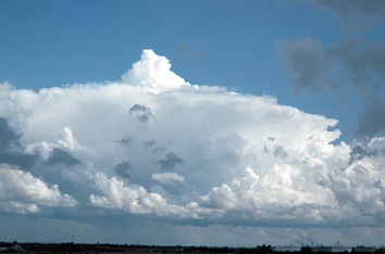
Figure 21-1 Cumulonimbus growing vertically.
Lightning and Thunder
Lightning is simply a discharge of static electricity that has built up in the cloud. The air along the path that the lightning follows experiences intense heating, causing it to expand violently. It is this expansion of air that produces the familiar clap of thunder. By definition, all thunderstorms have lightning — since it is the lightning which causes the thunder.
Thunderstorm Formation
Three conditions are necessary for a thunderstorm to develop, and they are:
1. strong instability in the atmosphere, so that once the air starts to rise it will continue to rise (for example, a steep unstable lapse rate with warm air in the lower levels of the atmosphere and cold air in the upper levels);
2. a high moisture content, so that clouds can readily form; and
3. a trigger action (catalyst or lifting force) to start the air rising, possibly caused by:
- a front forcing the air aloft;
- a mountain or other terrain forcing the air aloft (orographic ascent);
- strong heating of the air in contact with the earth’s surface causing convective ascent;
- heating of the lower layers of a cold polar air mass as it moves by advection to warmer latitudes, causing convective ascent and known as a cold stream thunderstorm;
- advection of cold air in an upper layer over warm air beneath, which will then tend to rise;
- less dense moist air moving up and over drier and denser continental air;
- cooling of the tops of large clouds at night by radiation which will cause the lower warmer air to rise (for instance, thunderstorms in tropical areas at night or in the early mornings);
- convergence, or low pressure air moving into a low pressure center rises, as it has no where else to go;
- mechanical lift — air moving over uneven terrain tumbles and eddies, creating rising air;
- dry line lifting, or a Marfa front; very common in New Mexico and Texas; or
- the jet stream, which can aid in lifting because the fast moving air provides low pressure aloft that sucks up air from below (behaves much like air in the throat of a carburetor where pressure is reduced and fuel is sucked into the venturi). Jet streams can also have an effect on the vorticity of rising storm cells.
Life Cycle of a Thunderstorm
1. The Cumulus Stage
As moist air rises, it is cooled until its dewpoint temperature is reached. Then the water vapor starts to condense out as liquid droplets, forming clouds. Latent heat is given off in the condensation process, and so the rising air cools at a lesser rate, with the release of large amounts of latent heat energy driving along the formation of the storm cloud. At this early cumulus stage in the formation of a thunderstorm, there are strong, warm updrafts over a diameter of one or two miles, with no significant downdrafts.
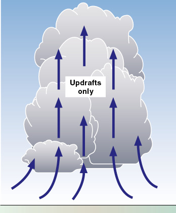
Figure 21-2 The cumulus stage in the development of a thunderstorm.
Air is drawn horizontally into the cells at all levels (this is called entrainment) and causes the evaporation of some of the water droplets chilling the air. This makes the air more dense, which contributes to the downdrafts that are beginning to develop in the cloud. The temperature inside the cloud is higher than the outside environment (because of the release of latent heat during the condensation), and the cloud continues to build to greater and greater altitudes. This growth often occurs at such a rate that an airplane cannot out-climb the growing cloud.
The strong, warm updrafts carry the water droplets higher and higher, to levels often much higher than the freezing level, where they may freeze or continue to exist as liquid water droplets in a supercooled state. The process occurring in cumulus cloud above the freezing level is called the “ice crystal” or Bergeron process; it is the main reason why cumulus clouds can produce extremely large volumes of large water droplets in the downpours associated with cumulonimbus clouds.
The cumulus stage as a thunderstorm forms typically lasts 10 to 20 minutes and is characterized by continuous updrafts. If the cumulus cloud develops into a towering cumulus 25,000 feet high in only 10 minutes, then the average updraft strength exceeds 2,000 fpm.
2. The Mature Stage
The water drops eventually become too large and too heavy to be supported by the updrafts, even though the updrafts may be in excess of 6,000 fpm, and so start to fall. As the drops fall in great numbers inside the cloud, they drag air along with them causing strong downdrafts. Some evaporation occurs as well, cooling the air and making it more dense within the rain shaft, which contributes to the strength of the downdraft. Often the first lightning flashes and the first rain from the cloud base will occur at this stage.
Rain starting to fall from the base of a cumulonimbus cloud to the surface is an indication that the thunderstorm has entered the mature stage, and it is in this stage that the thunderstorm reaches its greatest intensity.
The descending air warms adiabatically, but the very cold drops of water slow down the rate at which this occurs, resulting in very cool downdrafts in contrast to the warm updrafts. Heavy rain or hail may fall from the base of the cloud at this stage, generally being heaviest for the first five minutes. The strong wind currents associated with the thunderstorm may throw the hailstones well out from the core of the storm, possibly several miles where they may fall in clear air.
The top of a storm cloud in this mature stage may reach as far up as the tropopause, which is perhaps 30,000 feet MSL in temperate latitudes and 50,000 feet MSL in the tropics. The storm cloud may now have the typical shape of a cumulonimbus, with the top spreading out in an anvil shape in the direction of the upper winds. Extremely large cumulonimbus with strong vertical development can sometimes push through the tropopause and into the stratosphere. Over the Midwestern plains, some thunderstorms reach well above 50,000 feet MSL.
The violent updrafts and downdrafts (which are very close to each other in a mature thunderstorm) cause extremely strong windshear and turbulence, which can result in structural failure of the airframe. The rapidly changing direction from which the airflow strikes the wings could also cause a stall, so intentionally flying into a mature cumulonimbus cloud is a foolhardy thing to do.
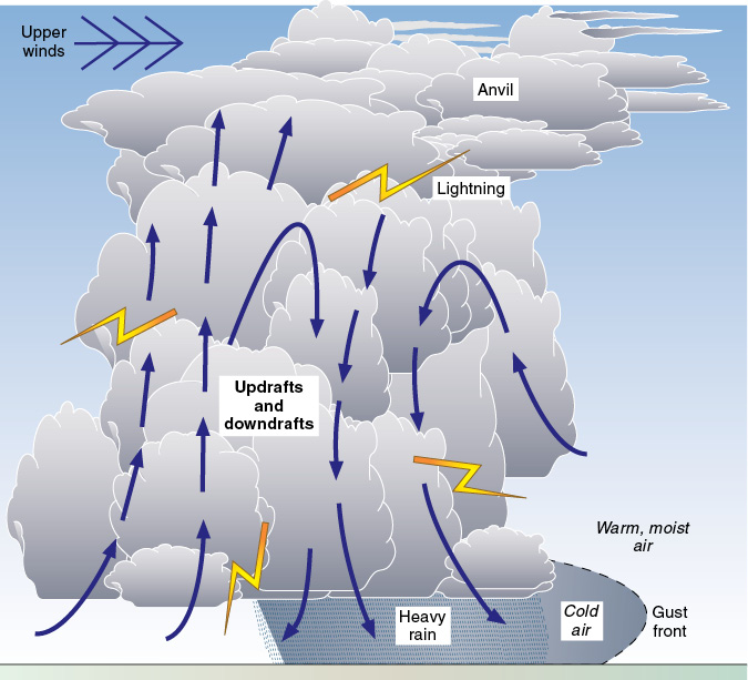
Figure 21-3 The mature stage.
As the cold downdrafts flow out of the base of the cloud at a great rate, they change direction and begin to flow horizontally as the ground is approached. Strong windshear and turbulence will occur — and this has caused the demise of many aircraft, large and small. The outflowing cold air will undercut the inflowing warmer air and, like a mini cold front, a gusty wind and a sudden drop in temperature may precede the actual storm.
Squalls may occur at the surface — a squall being defined as a sudden increase in wind speed of at least 15 knots, with the peak being at least 20 knots and lasting more than one minute.
A gust is less dramatic than a squall and is defined as a brief increase in wind speed of at least 10 knots.
A roll cloud may also develop at the base of the main cloud where the cold downdrafts and warm updrafts pass, indicating possible extreme turbulence.
The mature stage of a thunderstorm typically lasts between 20 and 40 minutes, and is characterized by updrafts and downdrafts, and by precipitation. There is so much water falling through the cloud toward the end of the mature stage that it starts to wash out the updrafts.
3. The Dissipating Stage
The cold downdrafts gradually cause the warm updrafts to weaken, thereby reducing the supply of warm, moist air to the upper levels of the cloud. The cool downdrafts continue (since they are colder than the ambient air surrounding the cloud) and spread out over the whole cloud, which starts to collapse from above. The dissipating stage of a thunderstorm is characterized by downdrafts. Eventually the temperature inside the cloud warms to reach that of the environment, and what was once a towering cumulonimbus cloud may collapse into stratiform cloud.
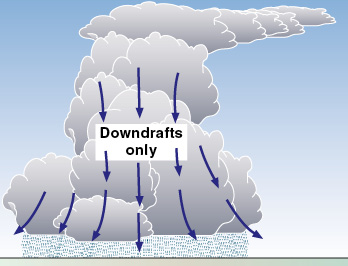
Figure 21-4 The dissipating stage.
Severe Thunderstorms
Sometimes severe thunderstorms develop, containing more than one storm cell, and with a prolonged mature stage of updrafts and downdrafts, with extremely strong windshears resulting. The cells within the one large storm may be at different stages in their life cycle. Strong winds aloft may cause the updrafts to slope. The rain and resulting downdrafts will be well-separated from the sloping updrafts, and so will not affect the updrafts and the moisture they are carrying up to the upper levels of the clouds. This can lead to the development of large cumulonimbus clouds and supercell thunderstorms. Multi-celled storms may grow into a very large phenomenon called a mesoscale convective complex, which can cover an area of several thousand square miles and persist for over 12 hours.
The strong downdrafts, on approaching the ground, tend to spread out in all directions, with the forward edge in front of the cloud forming a gust front. As the gust front advances, air is forced aloft and new storm cells can form.
Embedded Thunderstorms
Sometimes cumulonimbus clouds are embedded in a general cloud layer and, unlike many isolated and scattered thunderstorms, may not be detected by pilots flying visually below the clouds or by pilots flying without weather radar.
The presence of embedded thunderstorms might be indicated to a pilot flying visually beneath the cloud base by heavy rain showers. In general, however, you should not fly into or under a cloud mass containing embedded thunderstorms unless you have airborne weather radar or lightning detection equipment such as a Stormscope or Strikefinder (lightning has been associated with the severe turbulence found in thunderstorms).
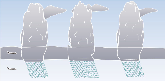
Figure 21-5 Embedded thunderstorms.
Icing
The most critical icing levels for airplanes inside a cumulonimbus cloud is from the freezing level (0°C) up to an altitude where the temperature is -15°C, the range where it is most likely to encounter supercooled water drops (freezing rain). If possible, avoid this temperature band inside clouds.
Hailstones
Large hailstones often form inside cumulonimbus clouds as water adheres to already formed hailstones and then freezes, leading to even larger hailstones. In certain conditions hailstones can grow to the size of an orange. Heavy hail can damage the skin of an airplane and damage its windshield.
Almost all cumulonimbus clouds contain hail, with most of it melting before reaching the ground where it falls as rain. Strong air currents can sometimes throw hailstones out of the storm for a distance of several miles. For this reason, pilots try to avoid severe thunderstorms by 20 NM. On cold days, with freezing level at or near ground level, hail will fall from the cloud and reach the ground before melting.
Lightning Strikes
Lightning strikes can cause damage to electrical equipment in the airplane and to the airplane skin and antennas. It can also temporarily blind the pilot, especially if flying at night in a darkened cockpit with the eyes adjusted to the darkness. A good precaution against this is to turn up the cockpit lights when in the vicinity of thunderstorms.
Lightning strikes seem to be most likely when flying in or near to cumulonimbus clouds at altitudes near the freezing level (±5°C, within about ±2,500 feet of the freezing level).
Turbulence
So that pilots and FSS can communicate efficiently regarding turbulence, certain classifications are used and should be generally understood.
- Light turbulence causes slight, erratic changes in attitude and/or altitude. Pilots may feel a slight pull from the seatbelt.
- Moderate turbulence causes some changes in attitude and/or altitude, and possibly in airspeed, but the aircraft stays in positive control at all times. Pilots will feel more pronounced pulls from the seatbelt.
- Severe turbulence causes large changes in attitude and/or altitude, probably with large changes in airspeed, and the aircraft may occasionally be momentarily out of control. Pilots will experience severe pulling from the seatbelt.
- Extreme turbulence causes violent changes in attitude and/or altitude and airspeed, with possible structural damage.
The duration of the turbulence can be described by:
- occasional — less than N of the time;
- intermittent — ⅓ to ⅔ of the time;
- continuous — more than ⅔ of the time.
Turbulence in the vicinity of a thunderstorm that causes large changes in attitude, altitude and airspeed, with the aircraft occasionally out of control for a moment, and causing you to experience severe pulling from the seatbelt for about three quarters of the time, would be described as continuous severe turbulence.
Downbursts and Microbursts
Strong downdrafts that spread out near the ground are known as downbursts. A very strong downburst not exceeding 2 NM in diameter is called a microburst.
Airplanes may not have the performance capability or the structural strength to combat the extremely strong downdrafts, turbulence and windshear in downbursts and microbursts, and can be destroyed. You should carefully avoid such weather phenomena.
Downbursts and microbursts are mainly associated with cumulonimbus clouds, but they may also occur with smaller clouds, such as cumulus, or with clouds from which virga is falling. As rain falls from high clouds and evaporates (virga), it absorbs latent heat and creates a very cold parcel of air beneath the cloud which may plummet toward the ground as a downburst or a microburst. This can sometimes be detected visually by a ring of dust being blown up where the microburst hits the ground and spreads out.
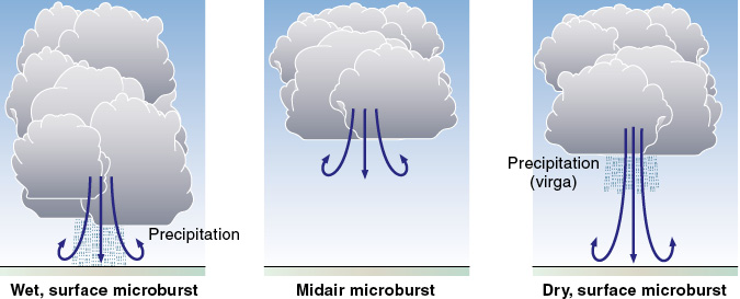
Figure 21-6 Some types of microbursts.
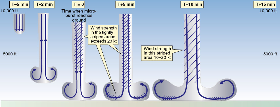
Figure 21-7 Typical life-cycle of a microburst.
Microbursts and downbursts may appear very suddenly and may or may not last very long. A typical life cycle lasts about 15 minutes from when the very strong shaft of downdrafts first strikes the ground. The wind spreads out horizontally in all directions, with the horizontal winds usually increasing in strength for the first 5 minutes and peak wind strength lasting 2-4 minutes.
Even though one airplane might make an approach satisfactorily underneath a large cloud, a following aircraft may not. There are a number of accidents to illustrate this. Always be on the watch for large clouds with a bulging undersurface, for virga, or for any other indication of downbursts or microbursts.
Effects of a Microburst on Aircraft Performance
Refer to figure 21-8. An aircraft entering the area of a microburst within 1,000-3,000 feet AGL will first encounter an increasing headwind. The aircraft will initially maintain its inertial speed over the ground (its groundspeed) and the increased headwind will cause it to have a higher airspeed, therefore increased performance. It will tend to fly above the original flight path. Then the aircraft will enter the downburst shaft and will be carried earthward in the strong downward air current — a loss of performance.
As the aircraft flies out of the downburst shaft (hopefully), the situation is not greatly improved. It will fly into an area of increasing tailwind. As the aircraft tends to maintain its inertial groundspeed initially, the increasing tailwind will cause the airspeed to decay — a reduced airspeed, resulting in reduced performance. Even with the addition of full power and suitable adjustments to pitch attitude by the pilot, the airplane may struggle to maintain a safe airspeed and flight path. Traversing small, strong microbursts safely may be beyond the performance capabilities of any aircraft.
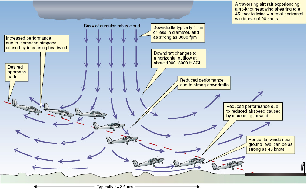
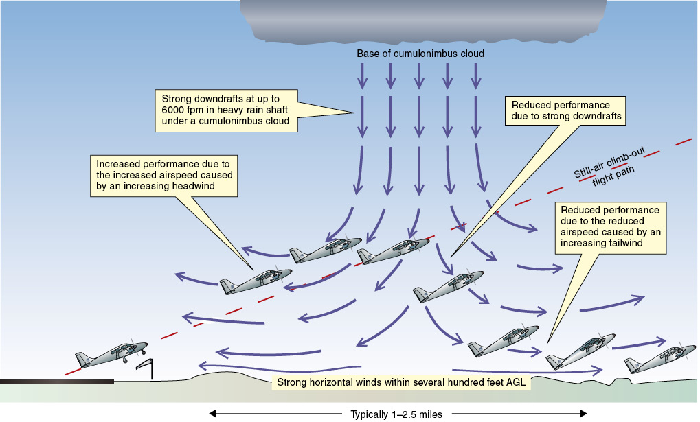
Figure 21-8 The dangers of a microburst in approach to land (top) and the dangers of a microburst following takeoff (below).
Tornadoes and Water Spouts
A strongly growing large cumuliform cloud may “suck” air into it as an updraft. These strong updrafts may start from just beneath the base of the cloud, or they may start well below the cloud base from near the ground, from where they may raise objects or, if over a water surface, cause a water spout. Tornadoes and water spouts are rotating funnels of air of very small diameter. The central pressure will be much lower than in the surrounding air, creating a vortex of wind with speeds possibly exceeding 150 knots. Tornadoes and water spouts are a great hazard to aviation. Avoid them at all costs!
Figure 21-9 A tornado.
Thunderstorms Are Hazardous to Aviation
The dangers to aviation from a thunderstorm do not exist just inside or just under the storm cloud, but for up to 10 or 20 NM or more. Most jet transport aircraft and advanced airplanes are equipped with weather radar to enable the pilots to identify the position of storm cells and to divert around them by an appropriate distance. The visual pilot without weather radar has to use the eyes and common sense. This may be difficult if the storms are embedded and rising out of a general cloud base or out of layers of clouds that obscure the storm clouds. Frequent lightning from within a cumulonimbus cloud, the presence of rain clouds, and the presence of a roll cloud indicate a severe thunderstorm.
SIGMETs are issued whenever possible to warn pilots of known or forecast thunderstorms and other meteorological hazards.
Some obvious dangers to airplanes from thunderstorms include:
- severe windshear (which may cause large flight path deviations and handling problems, loss of airspeed, and possibly structural damage);
- severe turbulence (causing loss of control and possible structural damage);
- severe icing (possibly the dangerous clear ice that forms from large supercooled water drops striking a below-freezing surface);
- damage from hail (to the airframe and to the cockpit windows);
- reduced visibility;
- damage from lightning strikes, including electrical damage; and
- interference to radio communications and radio navigation instruments.
The most severe flying conditions, such as heavy hail and destructive winds, may be produced in a squall line, which is a nonfrontal band of very active thunderstorms, possibly in a long line that requires a large detour to fly around. This line of thunderstorms (sometimes more than one line) can form in the relatively warm air ahead of a cold front, and can be quite fast-moving. A squall line may contain a number of severe steady-state thunderstorms, destructive winds, heavy hail, tornadoes, and can present a most intense hazard to aircraft.
In some parts of the U.S., such as the northern plains, the air is very clear and thunderstorms can be seen for many miles. However, in areas near the Gulf of Mexico the haze can be dense enough for it to be very difficult for a VFR pilot to see and avoid convective weather.
Flying Near Active Thunderstorms
Do not land or take off if there is an active thunderstorm approaching the airport. Sudden wind changes, severe turbulence and windshear are possible.
Avoid thunderstorms in flight by at least 10 NM and, in severe situations, by 20 NM. If you are passing downwind of them, you should perhaps increase this distance even further. Use your weather radar, Stormscope or Strikefinder, if available, otherwise detour visually making use of heavy rain showers, towering clouds, lightning, and roll clouds as indicators of where mature storm cells are likely to be.
It is very important you understand both how to use and the limitations of weather radar equipment. Poor education on the use of weather radar may be as bad as having none in the cockpit at all.
Remember that embedded thunderstorms may be obscured from sight by the general cloud layers, so avoid areas where embedded cumulonimbus clouds are forecast, unless you are equipped with a serviceable weather avoidance equipment. Also avoid areas with 6/10 or more of thunderstorm coverage. Any thunderstorm with tops 35,000 feet or higher should be regarded as extremely hazardous.
Fasten seatbelts and shoulder harnesses, and secure any loose objects in the cockpit. Turn up the cockpit lights at night to lessen the danger of temporary blindness from nearby lightning. Do not fly under thunderstorms, because you may experience severe turbulence, strong downdrafts, microbursts, heavy hail, and windshear. High-flying aircraft should divert upwind of the tops of thunderstorms if possible, avoiding flying downwind of or under the anvil, where there may be strong turbulence. Clearing the tops by 1,000 feet or more, if the airplane has the altitude performance capability, should avoid turbulence. A good rule-of-thumb is 1,000 feet of altitude above the tops for each 10 knots of wind speed at the cloud tops.
If you cannot avoid flying through or near a thunderstorm:
- Plan a course that will take minimum time through the hazardous area.
- Establish a power setting for the recommended turbulence penetration speed (which may be near the maneuvering speed, VA); the wing will stall before becoming overloaded, so flying at VA reduces the risk of structural damage.
- Turn on pitot heaters (to avoid loss of airspeed indication), carburetor heat or jet-engine anti-ice (to avoid power loss) and other anti-icing equipment (to avoid airframe icing).
- Maintain your heading by keeping the wings level with ailerons, and do not make sudden changes in pitch attitude with the elevators — just hold the pitch attitude steady and allow the altitude to fluctuate in updrafts and downdrafts (“ride the waves”). Sudden changes in pitch attitude may overstress the airplane structure. It may be advisable to disconnect the autopilot, or at least its altitude-hold and speed-hold functions, to avoid the autopilot making sudden changes in pitch attitude (causing additional structural stress) and sudden changes in power (increasing the risk of a power loss).
- Avoid turns if possible, as this increases g-loading — continue heading straight ahead and avoid turning back once you have penetrated the storm, as a turn will increase stress on the airframe and also increase the stall speed. Maintaining the heading will most likely get you through the storm in the minimum time.
- Allow the airspeed to fluctuate in the turbulence, and avoid rapid power changes.
- The most critical icing band within a cloud is from the freezing level (0°C) up to an altitude where the temperature is about -15°C, which is the temperature band where supercooled water drops may exist. Avoid this temperature band in large clouds if possible.
Monitor the flight and engine instruments, avoid looking out of the cockpit too much to reduce the risk of temporary blindness from lightning. Use the weather radar effectively, occasionally tilting the antenna up or down to allow detection of thunderstorm activity at altitudes other than the one being flown.
Note. You may sometimes experience St. Elmo’s fire, a spectacular static electricity discharge across the windshield, or from sharp edges or points on the airplane’s structure, especially at night. St. Elmo’s fire is not dangerous.
Review 21
Thunderstorms
1. What meteorological phenomenon do all thunderstorms have in common?
2. What are the requirements for the formation of a thunderstorm?
3. What does an unstable lapse rate mean?
4. Name the three stages of a typical thunderstorm.
5. What is the cumulus stage of a thunderstorm characterized by?
6. What is the growth rate of raindrops enhanced by?
7. What is the mature stage of a thunderstorm characterized by?
8. What is the dissipating stage of a thunderstorm characterized by?
9. What is rain falling from the base of a storm cloud an indication of?
10. What is an embedded thunderstorm?
11. Where are the most severe flying conditions, including heavy hail and destructive winds, often found?
12. Is hazardous windshear and turbulence possible on the outside of a thunderstorm cloud? If so, where?
13. If squalls are reported at your destination airport, you should expect:
a. a brief increase in wind speed of at least 10 knots.
b. heavy rain but no wind.
c. sudden increases in wind speed.
14. If gusts are reported at your destination airport, you should expect:
a. a brief increase in wind speed of at least 10 knots.
b. heavy rain but no wind.
c. sudden increases in wind speed.
15. What can airborne weather radar detect, when correctly used?
16. Do cumulonimbus clouds contain large water drops?
17. Can weather radar warn pilots of other possible instrument weather conditions, such as fog or stratiform clouds?
18. As a general rule, by what distance should you avoid severe thunderstorms?
19. For you to fly between two severe thunderstorms, how far apart (NM) should the thunderstorms be? How much separation from each storm does this distance enable you to maintain?
20. Can airborne weather radar be used to avoid all instrument weather conditions?
21. The downdraft in a microburst encounter may be as strong as:
a. 4,000 feet per minute.
b. 5,000 feet per minute.
c. 6,000 feet per minute.
d. 7,000 feet per minute.
e. 8,000 feet per minute.
22. The downdraft from a microburst will spread out within a few hundred feet of the ground, causing horizontal winds as strong as:
a. 5 knots.
b. 10 knots.
c. 45 knots.
23. How long can a typical microburst last from the time the burst strikes the ground until dissipation?
24. What is any change of wind speed and/or wind direction between two points called?
25. An aircraft faces a headwind of 45 knots as it enters a microburst. What is the aircraft likely to encounter?
26. An aircraft encounters a headwind of 45 knots near the surface as it enters a microburst. What is the total windshear across the microburst that can be expected?
27. Without a change in pitch attitude or power, what effect can entering a microburst and encountering an increasing headwind have on aircraft performance? What is the effect on airspeed and altitude?
28. In severe turbulence, will reducing the airspeed to the design maneuvering airspeed protect the wings from a potential overload?
29. Having entered a microburst, an aircraft flies from headwind conditions into a strong downdraft and then into a decreasing tailwind. What effect will this have on aircraft performance? Unless the pilot takes action, what is the likely effect on airspeed and altitude?
30. Refer to figure 21-10. Describe the effect on performance and the cause of this effect on the airplanes in the following positions:
a. Position 2.
b. Positions 4 and 5.
c. Position 6.
31. If you unintentionally penetrate a thunderstorm, what actions should you take?
32. If you enter an area of severe turbulence, what actions should you take?
33. If you fly into severe turbulence, you should attempt to maintain a constant:
a. airspeed.
b. level flight attitude.
c. altitude.
34. Refer to figure 21-11. Describe the effect on performance and the cause of this effect for the airplanes at the following positions:
a. Position 2.
b. Position 5.
c. Positions 7 and 8.
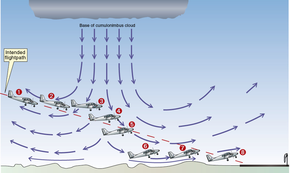
Figure 21-10 Microburst on approach.
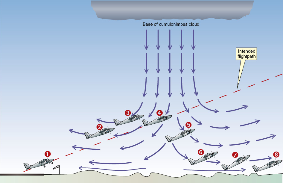
Figure 21-11 Microburst after takeoff.